Mypolonga via Murray Bridge (84 km from Adelaide)

Paddle Time 2-3 hrs (allow half day)

Easy – moderate
Approx 10 km, 2-3 hrs to half day
Always check weather and wind conditions before setting out.
Visit BOM for weather conditions
Easy – moderate - River and river backwaters
Do the five weather safety checks
Toilets and picnic area at the Paiwalla Reserve
Available at launch point
 Paddle SA is the governing body of paddle sport and recreation in South Australia. It leads and supports paddling in South Australia and encourages the safe exploration of our waterways.
Paddling Trail South Australia has a range of Paddling Trails to suit different abilities.
Know your ability.
 Trail 11
 If you have a smartphone or tablet you can download the free Avenza PDF Map app and have interactive paddling trail maps on hand when you need them. The app uses your device’s built-in GPS to plot your real-time location within the park onto a map. The app can be used without a network connection and without roaming charges. You can also measure area and distance, plot photos, and drop Placemark pins.
Launch Site:
Mypolonga Hill Road boat ramp (GPS 35.0485S 139.3625 E)
Trail Points:
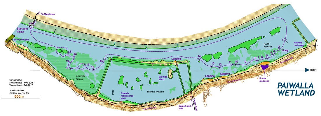
The trail starts at the Hill Road boat ramp Mypolonga. The wetlands are located on the right hand side of the river and commence at (Point A) 35.0974 S; 139.2956 E.
Paddlers follow this trail from the Boat Ramp by paddling up river for 5 km until a large dead Red Gum is sighted on the eastern side of the main river channel.
From the dead Red Gum, navigate towards the old farmhouse on the eastern bank, so entering the Paiwalla North Wetland.
Once in the wetland area markers lead the paddler through the trail:
Marker 1 – is attached to an old fence post about 100 m from the main river channel.
Marker 2 – A red buoy is attached. This marks a narrow channel entrance. Paddle downstream, adjacent to the river bank.
Markers 3 to 12 – pass through a series of small lagoons and clumps of reeds.
Inshore from marker 12 there is the option to take a break at an open area on the bank marked as ‘landings’ on the map. (Please note these areas are available for short day visits only and camping by the general public is not permitted.)
Marker 14 – head back towards the main river channel using a pump shed located on an embankment as a directional guide. An unmarked section of the trail follows the river downstream for approximately 1 km passing a large sluice gate which controls water to the main wetland.
Marker 15 – marks the entrance to Sunnyside Reserve.
Markers 15 to 20 – here the route meanders downstream through a series of lagoons. (Please note any park rules and restrictions)
Marker 21 – Re-enter the main river channel to return to the launch point (Hill road boat ramp Mypolonga).
 The Ancient Paiwalla (geological history)
Ancient sandstone cliffs, embedded with fossils, tower over the wetland.
Between ten and five million years ago sea-levels fell, revealing sandstone formations such as those in the Mannum Formation found at Paiwalla.
Subsequent erosion has created these cliff faces which contain large deposits of sea urchins (Lovenia forbesi) deposited on the sea-bed up to twenty-three million years ago and fossilised over time.
Paiwalla Swamp (recent history and development of this wetland area)
Prior to 1967, the Paiwalla Swamp of 116 hectares adjoined the Sunnyside Swamp of 34 hectares giving 150 hectares of continuous wetland, the largest wetland complex on the River Murray below Mannum.
In 1967 just over 60 hectares were reclaimed for dairy farming and other agricultural activities. Levee banks and irrigation channels were constructed and areas fenced. Regulators and sluice gates at the river’s edge controlled flooding of pastures.
By 1996 farming had ceased.
In the years between 1998 and 2002 volunteers removed fencing and an earth-moving firm was employed to fill the irrigation channels, and create islands and basins.
Exclusion screens were placed over the two inlet regulators to prevent European Carp from entering the wetland from the river. After an extended delay approval to inundate the area was received and the regulator valves were opened on 22 September 2003.
 Paddling Trail South Australia has a range of Paddling Trails to suit different abilities.
Know your ability
These are easy to access kayak and canoe trails through the Adelaide, Fleurieu Peninsula, Riverland, Murray River, and the Coorong.