


 https://canoeadventure.com.au/
Canoe Adventures Riverland hire and deliver kayaks in this area.
www.facebook.com/
 Paddle SA is the governing body of paddle sport and recreation in South Australia. It leads and supports paddling in South Australia and encourages the safe exploration of our waterways.
Paddling Trail South Australia has a range of Paddling Trails to suit different abilities.
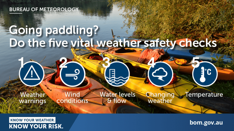
Know your ability.
Paddle SA is the governing body of paddle sport and recreation in South Australia. It leads and supports paddling in South Australia and encourages the safe exploration of our waterways.
Paddling Trail South Australia has a range of Paddling Trails to suit different abilities.
Know your ability.  If you have a smartphone or tablet you can download the free Avenza PDF Map app and have interactive paddling trail maps on hand when you need them. The app uses your device’s built-in GPS to plot your real-time location within the park onto a map. The app can be used without a network connection and without roaming charges. You can also measure area and distance, plot photos, and drop Placemark pins.
![]() Start at the Crooked Straight Campground (Murtho Forest Landing ) off the Murtho road.
Start at the Crooked Straight Campground (Murtho Forest Landing ) off the Murtho road.
Trail Notes:
This trail can be done in either direction.
The trail notes below describe a clockwise direction.
Turn left at the landing and go downstream about 6.25km to Point K (GPS 34.0829 S 140.7552 E) and turn right into Nelbuck Creek.
Follow this creek for about 3.5km and you will enter a large body of water (known as Ral Ral Wide Waters) at Point G (GPS 34.0894 S 140.7304E)
Note: if camping overnight there are good camp sites to be found on the banks of Ral Ral Wide Waters.
Turn right slightly across this body of water heading in a northerly direction for about 2km to the creek entrance on the LHS. This is shown at Point R (GPS 34.0751 S 140.7185 E)
Enter this creek and you will soon pass a large pumping station on the LHS. Keep well clear of it and travel for about 1.8km avoiding both the RHS and LHS branches at this point as they lead to dead ends. Instead take the middle route and continue on your way for about a further 3.5km and Calperum Station Headquarters will be seen on the LHS.
There is a road crossing at this point. Point Q (GPS 34.0456S 140.7144E)
You can obtain camping permits here.
Travel about 5km and you will reach the Windmill Bend campground next to Windmill creek at Point F (34.0414S 140.7511E)
The next T junction is about one km further along this creek, where it enters Big Hunchee Creek at Point D ( GPS 34.0464S 140.7614E)
(Note: A RH turn here will quickly take you back to the Murray River where you will emerge only a short distance downstream from the launch point)
Take the LH turn and continue along Big Hunchee Creek.
Note there are a number of campsites along the LHS of this creek and some have toilet facilities. There is also road access to this area from Calperum Station Biosphere Reserve. This area is very popular for bird watchers.
The next intersection is about 5km further along this creek, where you will come across Little Hunchee Creek on the RHS at Point C (GPS 34.0360 S 140.8040 E). There is good camping in this area with toilet facilities.
There are two options at this point
Go left for about 4k and you will return to the Murray River at Point P (GPS 34.0269 S 140.833 E) or
Turn right into Little Hunchee Creek for about 2.5k and you will enter the Murray river at Point B (GPS 34.0442 S 140.8217 E)
From either point it is a direct paddle downstream back to your launch point. Depending on which route you take the distance will be 10km or 14km.
NOTE: On the way back The Woolshed Brewery is located on an anabranch on the LHS accessed at Point A (GPS 34.0526 S 140.8274 E)
The spectacular Heading Cliffs will also be observed on the LHS as you approach your launch site.
Shady trees and safe overnight parking for cars.
A popular area for camping but there are no facilities
 Calperum Station
Check out the information about Calperum Station which is well recognised as an internationally significant wetland system.
Calperum Station and Taylorville Station form part of Riverland Biosphere Reserve, which is located north of Renmark in the Riverland area of South Australia.
The Riverland Biosphere Reserve was previously known as the ‘Bookmark’ Biosphere Reserve, a name derived from the Aboriginal word Pukumako meaning flint stone axe or sandstone grit hole.Calperum and Taylorville are important locally, nationally and internationally because of their intact mallee vegetation, the presence of several threatened bird species, and their wetlands and related species.  The properties form critical habitat for the endangered black-eared miner (Manorina melanotis). They are also important for the conservation of the nationally vulnerable malleefowl (Leipoa ocellata), the regionally vulnerable bush stone-curlew (Burhinus grallarius) (pictured) and the nationally vulnerable southern bell frog (Litoria ramiformis).
